|
|  A walk round lockdown Exeter |

|

After two years of lockdown, as we finally emerge from Covid-19, we find that all the heritage sites remain intact and so, retaining the theme of lockdown, this walk round central Exeter is repurposed for Heritage Open Days 2022.
Starting where the High Street, Sidwell Street and Paris Street meet, this walk takes us round most of the city's main historic sites against the background that in many respects Exeter was been locked down not just for two years but for almost two millennia.
Starting where the High Street, Sidwell Street and Paris Street meet, this walk takes us round most of the city's main historic sites against the background that in many respects Exeter was been locked down not just for two years but for almost two millennia.
While the route is generally safe, there are some
steps and also busy streets to cross. Participants follow this route at
their own risk and the compilers will not be responsible for any injuries
suffered. Some sections of the route may be crowded and you are advised to wear face covering if social distance cannot easily be maintained.
1. East Gate. Look down the High Street and imagine the massive gate blocking the way to a High Street that until the 1940s was much narrow than it is today. Until 1784 the traveller arriving at Exeter by way of the Roman road through Honiton then along the Heavitree Road and Paris Street would be confronted with this medieval gateway, one of four that had been the only means of passing through the Roman walls since the second century of our era. They had effectively quarantined Exonians in times of war and pestilence and in medieval times the gates were closed each day at sunset.We turn down Paris Street to reach our second stop. The street name, first recorded in 1422 is thought to derive from a Norman French word meaning an enclosure, a recurring theme of this walk.

Aquatint, 1785. SC0903. Westcountry Studies Library
2. Underground passages. These are remnants of the city's medieval water supply, which ran from wells outside the city through Longbrook Street, and under the protective city walls to Catherine Street and the cathedral. It was first constructed in the 13th century and was followed by another built by the city authorities in 1420, which ran under the High Street to the Great Conduit at Carfax. Exeter is the only city in Britain to have underground passages of this type. We turn right into Princesshay to find the city walls.
3. City walls. The corner tower, an unusual pentagonal bastion, shows traces of many repairs through the centuries. At the end of the second century the Romans threw up an earthen rampart 2.5 kilometres in length around the town and at the start of the third century the city walls were built on the same line. In many places the original Roman masonry can still be found. We continue to the left, outside the city walls, passing to the left of Southernhay United Reformed Church to our next stop.
4. Dix's Field. In the 18th century Exeter became a major industrial and commercial city and much of this activity took place outside the city walls. Dix's Field was built in 1808 for merchants and higher professional classes. The northern side of the street was destroyed by bombing in 1942. In 1821 a neo-classical bathhouse was opened on the corner with Southernhay. This was replaced by the Congregational Church in 1868. We follow our route down Southernhay East.
5. Southernhay. Although now an open space, Southernhay was also originally an enclosed area. The place-name element "hay" is cognate with the word "hedge" and means an area of land enclosed by a hedge. This area was developed outside the city walls between 1798 and 1820 and, despite parts of it suffering during the 1942 blitz and from unsympathetic rebuilding afterwards, we can still admire the dignified architecture. On Chichester Place, the first terrace of buildings we pass, is a blue plaque to the pioneering folk song collector and polymath Sabine Baring-Gould (1834-1924). On the left where Barnfield Road crosses can be seen the Victorian Barnfield Theatre, opened as Barnfield Hall by the Exeter Literary Society in 1894. Further along Southernhay many of the buildings have decorations in Coade stone, an artificial stone developed by Eleanor Coade who was born in Exeter in 1733. Our walk passes examples of Coade stone on nos. 33-35. We continue down Southernhay to Dean Clarke House.
6. Royal Devon and Exeter Hospital. The Royal Devon and Exeter Hospital was founded in 1741 by Exeter's recently appointed dean, Alured Clarke. A hospital with 30 beds was built within 16 months, not quite up to Nightingale Hospital standards in 2020, but Dean Clarke did not live to see its completion. In early days the patients had to help pump the hospital water. The original building, renamed Dean Clarke House when the Hospital moved to Wonford in 1974, now has a variety of uses, with flats, offices and restaurants occupying the eighteenth-century building. We cross Southernhay from Dean Clarke House and take the footpath opposite, to the city walls.
7. City walls. There is an impressive stretch of the city walls at this point, with bastions which were added probably in the 13th century. We turn right to follow the walls and up a short flight of steps to turn left into the Cathedral Close. A new passage to the Cathedral Close was made in 1753 when a tower in the wall was demolished, and the cast iron Burnet Patch bridge was erected in 1814 to enable the perambulation of the city walls.

John Hooker's Plan of Exeter Cathedral Close
Annotated to show the position of the gates
8. Cathedral Close. We are now entering a city within a city. Following the murder of the Precentor Walter Lechlade in 1283 a visit was made by King Edward I in 1285 to celebrate Christmas and to preside over the trial of those accused of Lechlade's murder. The King signed a royal licence on 1 January 1286 allowing the cathedral authorities to construct a 12ft high security wall around the entire cathedral precinct. This wall was pierced by seven gates, which were locked every evening; from left to right: Palace Gate, Bear Gate, Little Stile and St Petrock's Gate from South Street, Broad Gate, the main entrance, and St Martin's Gate from the High Street, and St Catherine's Gate from Catherine Street. The walls were demolished and houses built on their site but the gates remained until their demolition between 1812 and 1825. At the entrance to The Cathedral Close you can see on the right the Deanery at no. 10, a building always owned by the Cathedral and occupied over the centuries by the Chancellor, Treasurer, Head Verger and Bishop of Crediton. Its massive oak door dating from around 1600, leads into a charming little quadrangle; this is private but can sometimes be glimpsed when the door within the door is left ajar.

9. Courtenay House. No. 7 Cathedral Close dates from 1643 and was the town house of the Courtenay family, the Earls of Devon. It now serves as the library of the Devon and Exeter Institution, founded in 1813 and still with the atmosphere of a Victorian gentleman's club.
10. Mol's coffee house. Rebuilt around 1596, no. 1 Cathedral Close served as a customs house until 1660, and in 1726 was leased as a coffee house by Mary Wildy, perhaps the Mol whose name it bears. The iconic gable was only added in 1879 by Thomas Burnett Worth who ran an art gallery there. The house has a well-preserved panelled room.
11. St. Martin's Church. The church was dedicated to the fourth century Bishop of Tours in 1067, perhaps due to the influence of Leofric, the first Bishop of Exeter. It was rebuilt in the 15th century. St Martin's Gate blocked off Martin's Lane, on the left side of which stood the Exeter Bank, established in 1769 and later incorporated in the Royal Clarence Hotel.
12. The Royal Clarence Hotel. The hotel was destroyed in a fire in October 2016 and it is hoped that the old facade can be rebuilt. It was first described as "The Hotel" in 1770 by Peter Berlon, a French hotelier who was in Exeter from 1766 until 1774. This is the first use in England of the word hotel to describe an inn. In 1827 the Duchess of Clarence stayed here on her way to Plymouth and it was renamed in her memory. We turn right along Catherine Street and stop at the ruined buildings on the right.
13. Saint Catherine's Almshouses. The almshouses and the chapel of St. Catherine were started by canon John Stephens in about 1457. A crack running down the end wall of the chapel results from subsidence into the ditch of the Roman legionary fortress, constructed in about 55 CE - the earliest enclosed area in the City of Exeter. We turn left to go through the archway into the High Street and then turn left again.
14. Saint Stephen's Church. This is mentioned in the Domesday Book 1086, and it has a Saxon crypt. The bow or archway over the road probably results from rebuilding in the early 13th century. During the Commonwealth the church was auctioned for £250 in 1656, and the crypt was used as a stable. The present church results largely from rebuilding in 1662 after a fire.
15. High Street. The eastern end of the High Street was widened after it was razed following the wide-spread destruction of the area in the 1942 bombings. The historical charm of the buildings in the narrower section of the High Street lies above the shop windows. The earliest facades are nos. 41-2 which bear the date 1564. Nos. 39-40 date from around 1690 and no. 46 from the early 16th century. On the north side numbers 225-226 date from 1567 and 227 from the middle of the 17th century. On the wall of no. 229 is a blue plaque to Sir Thomas Bodley, founder of the Bodleian Library, who was born in the house on the corner of Gandy Street in 1545.
16. Queen Street. This is a new street and was cut through in 1835. The Higher Market, an imposing building in Classical style, opened its doors for the first time in 1838, and was originally locked at 10.30 pm each day. However we continue along High Street and turn right along Goldsmith Street and left along Waterbeer Street.
17. St Pancras Church. The little church once stood on Pancras Street, a narrow lane which used to zig-zag its way across the smallest parish in Exeter in what is now the Guildhall Centre. It may be one of the earliest churches in Exeter, with traces of a Saxon doorway. The medieval church was sold for £50 with its bell in 1658, but it was repurchased by the parish. It was subsequently neglected and crowded in and its survival is something of a miracle. We continue along Waterbeer Street and turn left into Parliament Street.
18. Parliament Street. This is Exeter's narrowest street and is believed to be the narrowest in England. It is said to have got its name around 1832 as a joke during parliamentary reforms. In 1836, the residents of Waterbeer Street raised £150 to widen the street, but nothing came of it. At its narrowest point it is just 64 cm wide, beating Stone Street in Prescot at 71 cm. As for Squeezegut Lane in Whitstable and Squeezebelly Alley in Kingsbridge, despite their names they are even wider. When we reach the High Street, Saint Petrock's church is diagonally to our right and beyond that is Carfax, the crossing point for the streets that converge from Exeter's four gates. The Great Conduit stood here until the 1770s, a main source of water for central Exeter. In front of us is the opening onto the Cathedral Close where Broadgate used to stand.

19. Saint Petrock's Church. The church is named after the Celtic saint. After many changes, the church has a confusing plan with the altar on the south side. Now partitioned internally, part of it serves as a charity supporting Exeter's homeless. We turn left up the High Street.
20. Guildhall. Exeter's Guildhall was rebuilt in the middle of the fifteenth century and the Renaissance facade with columns was added in 1593. It is the meeting room for the city council and contains the mayor's reception room and the civic regalia. It also served as a court of justice and contained a police station and prison lock-up. The heavy doors are often open to allow visits. We return along the High Street to enter the Cathedral Close through Broadgate.

We make for the far right corner of the Close beyond the County War Memorial. Through a gateway we can glimpse the remains of gothic arches.
21. Kalendarhay (another enclosure) housed the College of Vicars Choral or Kalendars whose duty was to sing during services in the Cathedral. Their medieval buildings, a smaller version of the Vicars' Close in Wells, were destroyed in 1942. The remains are better viewed from South Street.
22. St Mary Major Church with its massive nineteenth-century spire was demolished after the war when a Roman bath house for the legionaries, which has now been filled in again, was found in front of the cathedral. All that can now be seen in situ is a plaque on a nearby wall. We turn to admire the west front of the Cathedral.
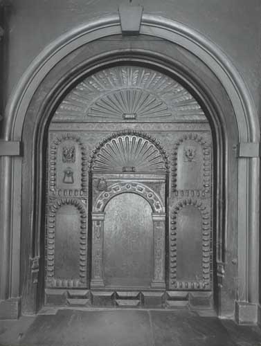
Oak door to Exeter Cathedral Deanery
Photograph taken 1908 for Exeter Pictorial Record Society, Westcountry Studies Library
In the former Law Library, at no. 8 Cathedral Close, it is sometimes possible to view the wonderful fifteenth-century hammer-beam roof, supported by carved stone corbels, with moulded timbers with carved angels and lions and ornamented with bosses.9. Courtenay House. No. 7 Cathedral Close dates from 1643 and was the town house of the Courtenay family, the Earls of Devon. It now serves as the library of the Devon and Exeter Institution, founded in 1813 and still with the atmosphere of a Victorian gentleman's club.
10. Mol's coffee house. Rebuilt around 1596, no. 1 Cathedral Close served as a customs house until 1660, and in 1726 was leased as a coffee house by Mary Wildy, perhaps the Mol whose name it bears. The iconic gable was only added in 1879 by Thomas Burnett Worth who ran an art gallery there. The house has a well-preserved panelled room.
11. St. Martin's Church. The church was dedicated to the fourth century Bishop of Tours in 1067, perhaps due to the influence of Leofric, the first Bishop of Exeter. It was rebuilt in the 15th century. St Martin's Gate blocked off Martin's Lane, on the left side of which stood the Exeter Bank, established in 1769 and later incorporated in the Royal Clarence Hotel.
12. The Royal Clarence Hotel. The hotel was destroyed in a fire in October 2016 and it is hoped that the old facade can be rebuilt. It was first described as "The Hotel" in 1770 by Peter Berlon, a French hotelier who was in Exeter from 1766 until 1774. This is the first use in England of the word hotel to describe an inn. In 1827 the Duchess of Clarence stayed here on her way to Plymouth and it was renamed in her memory. We turn right along Catherine Street and stop at the ruined buildings on the right.
13. Saint Catherine's Almshouses. The almshouses and the chapel of St. Catherine were started by canon John Stephens in about 1457. A crack running down the end wall of the chapel results from subsidence into the ditch of the Roman legionary fortress, constructed in about 55 CE - the earliest enclosed area in the City of Exeter. We turn left to go through the archway into the High Street and then turn left again.
14. Saint Stephen's Church. This is mentioned in the Domesday Book 1086, and it has a Saxon crypt. The bow or archway over the road probably results from rebuilding in the early 13th century. During the Commonwealth the church was auctioned for £250 in 1656, and the crypt was used as a stable. The present church results largely from rebuilding in 1662 after a fire.
15. High Street. The eastern end of the High Street was widened after it was razed following the wide-spread destruction of the area in the 1942 bombings. The historical charm of the buildings in the narrower section of the High Street lies above the shop windows. The earliest facades are nos. 41-2 which bear the date 1564. Nos. 39-40 date from around 1690 and no. 46 from the early 16th century. On the north side numbers 225-226 date from 1567 and 227 from the middle of the 17th century. On the wall of no. 229 is a blue plaque to Sir Thomas Bodley, founder of the Bodleian Library, who was born in the house on the corner of Gandy Street in 1545.
16. Queen Street. This is a new street and was cut through in 1835. The Higher Market, an imposing building in Classical style, opened its doors for the first time in 1838, and was originally locked at 10.30 pm each day. However we continue along High Street and turn right along Goldsmith Street and left along Waterbeer Street.
17. St Pancras Church. The little church once stood on Pancras Street, a narrow lane which used to zig-zag its way across the smallest parish in Exeter in what is now the Guildhall Centre. It may be one of the earliest churches in Exeter, with traces of a Saxon doorway. The medieval church was sold for £50 with its bell in 1658, but it was repurchased by the parish. It was subsequently neglected and crowded in and its survival is something of a miracle. We continue along Waterbeer Street and turn left into Parliament Street.
18. Parliament Street. This is Exeter's narrowest street and is believed to be the narrowest in England. It is said to have got its name around 1832 as a joke during parliamentary reforms. In 1836, the residents of Waterbeer Street raised £150 to widen the street, but nothing came of it. At its narrowest point it is just 64 cm wide, beating Stone Street in Prescot at 71 cm. As for Squeezegut Lane in Whitstable and Squeezebelly Alley in Kingsbridge, despite their names they are even wider. When we reach the High Street, Saint Petrock's church is diagonally to our right and beyond that is Carfax, the crossing point for the streets that converge from Exeter's four gates. The Great Conduit stood here until the 1770s, a main source of water for central Exeter. In front of us is the opening onto the Cathedral Close where Broadgate used to stand.

South view of the Broadgate at Exeter
Engraving, 1822. SC0898, Westcountry Studies Library
20. Guildhall. Exeter's Guildhall was rebuilt in the middle of the fifteenth century and the Renaissance facade with columns was added in 1593. It is the meeting room for the city council and contains the mayor's reception room and the civic regalia. It also served as a court of justice and contained a police station and prison lock-up. The heavy doors are often open to allow visits. We return along the High Street to enter the Cathedral Close through Broadgate.
Guildhall door from outside
Photograph taken 1913 for Exeter Pictorial Record Society, Westcountry Studies Library
We make for the far right corner of the Close beyond the County War Memorial. Through a gateway we can glimpse the remains of gothic arches.
22. St Mary Major Church with its massive nineteenth-century spire was demolished after the war when a Roman bath house for the legionaries, which has now been filled in again, was found in front of the cathedral. All that can now be seen in situ is a plaque on a nearby wall. We turn to admire the west front of the Cathedral.
23. Exeter Cathedral. Around 670 a monastery was founded at this point, where St Boniface was brought up before he started his missionary work in Germany. Bishop Leofric moved his seat from Crediton to Exeter in 1050. From 1112, the Norman conquerors built a new cathedral in Romanesque style of which the square towers remain. From 1270 a new Gothic style renovation began, which was completed 100 years later with the west front. The 88 figures on the west front probably represent the kings of Judah from the house of Jesse together with the prophets, apostles, angels and saints. A representation of the Virgin Mary was mistakenly replaced by a statue of Richard II in 1817. We continue to the right of the Cathedral along the road leading to Palace Gate.
24. The Old Deanery. Formerly the Dean's residence, which partly dates from the 13th century, this was where the court of Prince William of Orange was held in 1688 after his arrival from Holland to take the throne as William III. The printing press that he brought with him was installed here. It is now the Diocesan Office. Opposite are the remains of the cloisters. In the range of cloisters along the south wall of the cathedral, more than 300 illuminated manuscripts of the Cathedral Library were securely locked down with chains on eleven desks in medieval times. We continue down Palace Gate.
25. The Bishop's Palace has been neglected and restored many times. Once it was used as a sugar refinery but now houses the Cathedral Library and Archives which contain many treasures, particularly a regional section of the 1086 Domesday Book and a collection of Old English poems from around 970 that Leofric brought to Exeter.
.jpg)
Gatehouse to Bishop's Palace
The gateway to the Bishop's Palace is not Palace Gate, which was located at the entrance from South Street; the entrance to the Bishop's garden, it shuts off an enclosure within an enclosure within an enclosure.
26. Palace Gate. Johann Baring lived in Palace Gate Street from 1728 to 1737. Born in Germany, he was the founder of an important wool trade business. Baring's Bank, the important commercial bank which collapsed ignominiously in 1995 was founded in London by his son Francis with his brother John a sleeping partner who distanced himself in Exeter from the London bank's involvement in the slave trade, voting for its abolition in 1796. We continue to High Street, cross the road and turn left.
26. Palace Gate. Johann Baring lived in Palace Gate Street from 1728 to 1737. Born in Germany, he was the founder of an important wool trade business. Baring's Bank, the important commercial bank which collapsed ignominiously in 1995 was founded in London by his son Francis with his brother John a sleeping partner who distanced himself in Exeter from the London bank's involvement in the slave trade, voting for its abolition in 1796. We continue to High Street, cross the road and turn left.

28. South Gate. The outline of the massive towers is marked on the pavement. The rooms above the South Gate were used as a city prison until the gate was demolished in 1819. It is said that the debtors, who were also locked up here, lowered a shoe on a cord to collect money from charitable travellers - literally living on a shoe-string. From the former south gate Magdalen Street leads east past the mid fifteenth-century Wynard's almshouses on the left and the late nineteenth-century Eye Infirmary on the right to Bull Meadow where the Magdalen Hospital stood in medieval times. Lepers were safely isolated here on the far side of the Shitbrook; none of the inmates could cross the bridge without the warden's special permission, on pain of being put in the stocks. We take the footbridge over Western Way and turn right at the foot of the stairs to follow the footpath alongside the city wall.
29. Water Gate. This was built into the city wall in 1565 to allow better access to the quay area and the port facilities which were then being improved. It was demolished in 1815. We make our way to the front of the Custom House.

Engraving, 1822. SC0917. Westcountry Studies Library
30. The Custom House. The Custom House was the first brick building in the city. It was built in 1677–1681 on the former Roman quay. The beautiful portico, where goods were stored before customs clearance, has now been bricked up but the interior has the King's pipe, where contraband tobacco and other goods were burned, and wonderful plaster ceilings by John Abbot of north Devon. Goods were later stored in bonded warehouses around the quay area. From left to right in front of the Custom House we can see the Wharfinger's House, built in 1778 when business in the port expanded, the Quay House built around 1600, the Prospect Inn, which can be traced back to the 1820s as the Fountain Inn, the warehouses that were built in the 1830s, the former fish market with the King's beam, now an antiques centre and, across the leat, the nineteenth-century bonded warehouses. We pass the bonded warehouses, cross the suspension bridge and turn left.
31. The Canal Basin. Exeter's ship canal was dug in 1566 after Exeter's route to the sea was blocked with a weir constructed by the Countess of Devon Isabella de Fortibus, probably around 1284. In 1676, the improvement of the canal enabled a large expansion of the sea trade and a sixth of all English wool exports went through Exeter. The canal basin was opened in 1830, but with the extension of the railway lines to Exeter in 1844, a decrease in traffic on the canal ensued. Set into the pavement by the nearer turntable, three rails leave a rare trace in situ of Brunel's broad gauge Great Western Railway which reached the quayside. We return over the footbridge and then turn left along Commercial Road.
32. Shilhay. This area was the city's former industrial district. The many textile mills have long since disappeared and with them most of the leats that supplied their water. We turn right and pass between the Bishop Blaize, named after the patron saint of woolcombers, and Cricklepit Mill, now occupied by Devon Wildlife Trust. The mill preserves its waterwheels and has been operating on the site since the late 12th century, largely as a grain mill. Shilhay and the west quarter suffered disproportionately during the cholera epidemics of 1832-1834 as the map below indicates. Clothes of the victims were burned and buried on Shilhay island.

Map of Exeter in 1832 shewing the localities where the deaths caused by pestilential cholera occurred in the years 1832, 1833 & 1834.
Annotated extract from the earliest known map of its kind, drawn up by Thomas Shapter.
33. Exe bridge. St Edmund's Church stands on the remains of the medieval Exe Bridge which still retains the arches of the first stone bridge built in the 12th century. Later bridges were built in 1778, 1904 and the present double bridge in 1969-1972. We return and cross Western Way to the site of the West Gate.
34. West Gate. A plaque marks the site of the gate which was demolished in 1815. Stepcote Hill was the main road from the city centre through the West Gate until 1778 when Allhallows Church was demolished and New Bridge Street continued the line of Fore Street beyond the city walls. The gatekeeper's home is still there; the entrance can be found to the right of the church door.

Steel line engraving, 1831. SC0918. Westcountry Studies Library
35. The House that Moved. This is a half-timbered house from around 1430, once neglected, but in 1964 it was lifted up and transported 70 meters on rails when Western Way was built.
36. St Mary Steps. The church dates back to the 15th century, but its Norman baptismal font from around 1150 is still preserved. The clock dates from 1617 and is known as Matthew the Miller. It has been maintained by Exeter Civic Society. We pass up Stepcote Hill and turn left along King Street, pausing to look at King's Dwelling a refurbished example of early social housing. A blue plaque commemorates Dr Charles Newton Lovely, founder of the Exeter Workmen's Dwellings Company. We cross Fore Street and descend for a few yards.
37. Tuckers' Hall. The guild house of the Guild of Weavers, Tuckers and Shearmen was built in 1471. There used to be twelve guilds in Exeter and this is the only one to survive. Its hall with a fascinating display on the history of Exeter's wool trades is sometimes open to the public.
38. 143 Fore Street. Constructed 1714-1716 by the fuller Thomas Bury, this was later the magnificent home of Sir John Duntze, whose family came from Bremen, and who made a fortune in the wool trade. A blue plaque commemorates Thomas Latimer, the radical journalist of the Western Times and his friend Charles Dickens. We continue up Fore Street and turn left into the Mint.
39. The Mint. This narrow lane is named after a mint that was established here to assist in the great recoinage of 1696. Previously it had been called St Nicholas Lane. Further along the Mint the remains of a monastic complex lie on both sides of the lane.
40. St Nicholas Priory was a Benedictine monastery founded in 1087 on land given by William the Conqueror. The west wing is the oldest house in Exeter. The monastery was closed in 1536, not without the resistance of the Catholic women of Exeter who pounced on the men who were sent to demolish the building. On the other side of the lane, the garden is on the site of the cloisters with the north wing of the monastery to the left and a later Catholic chapel at the far side. We continue along Bartholomew Street East, keeping the old Allhallows Churchyard on our left and cross the road at the corner to look across the Lower Cemetery and Longbrook valley to St Michael's Church.
41. The catacombs which lie beneath our feet were built in the Egyptian style which became fashionable after Nelson's victory on the Nile in 1798. After the first funeral in 1811, only fourteen people were buried here and the speculative undertaking failed.
42. The Old Malthouse used to belong to St Anne's Well Brewery. It malted barley for the last time in 1966. We continue to the crossroads and turn left into Lower North Street.
43. North Gate. The North Gate, demolished in 1769, led out to a steep incline in the Longbrook valley which was only bridged in the 1830s.

Steel line engraving, 1831. SC0907. Westcountry Studies Library
The iron bridge cast at the Blaina works in Monmouthshire was built in 1835 to overcome the steep slope of the main road. We can go carefully down the steps on the right-hand side of the bridge to return by the lower level. A little up the hill a seventeenth-century farmhouse has survived at nos. 31-33 Lower North Street and the large brick building was formerly St Anne's Well Brewery. We turn left up Northernhay Street, lined with attractive early nineteenth-century houses, to reach Queen Street.
44. Exeter Dispensary. The Dispensary, founded in 1818, opened the doors of its new building at 26 Queen Street in 1843, but not the front entrance. This could not be used by the poor, who were undoubtedly grateful enough to come through the back entrance. The pharmacy was particularly active in 1849, when almost 500 citizens died of cholera within three months. To the left is the massive Victorian bulk of Rougemont Hotel opened in 1879, built on the site of the Exeter Borough Prison, which occupied the site from 1819, when Southgate Prison was demolished, until 1863 when it was closed and the prisoners moved to Devon County Gaol. Queen Street leads on past Central Station (opened 1860) to the clock tower, Exeter College, the University campus and also to Bury Meadow, where most of the cholera victims were buried in the 1830s. We turn right toward the city centre.
45. The Royal Albert Memorial Museum was opened in 1869 as a monument to the Prince Consort of Queen Victoria, who died in 1861. A major cultural and educational center, the Royal Albert Memorial developed not only the museum but also the city library, the College of Art, now part of the University of Plymouth, and the University College of the South West, now the University of Exeter. We turn left past the Museum into Gandy Street where the Exeter Phoenix arts centre occupies the former University College building. We continue along picturesque Gandy Street (which some have seen as the inspiration for Diagon Alley in J.K.Rowling's Harry Potter, although the author denies this) and turn left up New Buildings to pass behind the Central Library and enter Rougemont Gardens. These were formerly the gardens of Rougemont House and were acquired by the city in 1912. We follow the paths to the left toward the city walls.
46. Athelstan's tower. This was named much later after King Athelstan, who ruled from 924 to 939 and improved the Roman defences in about 929. Most of the city walls were also repaired around 1377 when the French threatened to occupy Exeter. The gate through to Northernhay Gardens is currently closed but they can be visited later on our walk.
47. Rougemont House. This elegant town house was built around 1769 for John Patch, a surgeon from Devon and Exeter Hospital, and was bought by the city in 1911.

John Norden's plan of the Castle Precinct in 1617
Little Castle Street leads down towards the High Street. The Timepiece night club occupies the site of the County Gaol until 1794. We turn left into Bailey Street and left again into Northernhay Place.
49. Northernhay Gardens. Northernhay, another former enclosure to match Southernhay on the other side of Exeter, was designed as a public park in 1612. It houses a number of statues and public works of art as well as the city's war memorial. Across the Longbrook valley along which the railway runs to Exeter Central Station is the site of yet another fortification. Danes Castle was built by King Stephen in 1136 as an earthen stronghold when he was besieging Baldwin de Redvers in Rougemont Castle. Just in front of it is a much more prominent stronghold, Exeter Prison. This was built by the prolific architect John Hayward and was opened in 1853. It replaced the County Gaol, which had been opened on the same site in 1794, where public executions were held.
We return down Northernhay Place and through Roman Passage on the other side of Bailey Street which brings us back to the High Street and the site of East Gate where our tour began.
This tour was originally designed for German visitors to Exeter. It was translated back into English, edited and extended during lock-down in 2020. The illustrations of the gates are taken from images produced for the Etched on Devon's Memory Heritage Lottery Fund Project from originals in the Westcountry Studies Library. The links are mainly to the excellent and wide-ranging Exeter Memories website, but others have been used where appropriate, including the Demolition Exeter website (now discontinued) and the Exeter Civic Society website. I am most grateful to Exeter historian Hazel Harvey for reading and correcting the text.
Ian Maxted
Last updated 14 August 2022